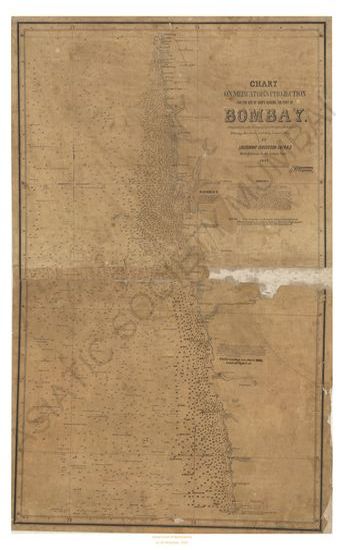
Bombay chart of Mercator's projection for the use of ships making the port of Bombay
| Resource Type | : | Map |
| Year/Date of Publication | : | 1852 |
| Subject | : | Topographic Map |
| Language | : | English |
| Pages/Folios | : | 1 Map |
| Identifier | : | MAP_0039 |
| Digitization Sponsor | : | Government of Maharashtra |
| File Size | : | 5.4 M.B. |
Other Similar Items
-
- A Treatise on the Cycloid and all forms of Cycloidal Cu ...
- Year: 1878
- Author: Proctor, Richard A.
-
- An Authentic Account of an Embassy from the King of Gre ...
- Year: 1798
- Author: Earl of Macartney; Gower, Erasmus Sir; Staunton, et al.
-
- An Authentic Account of an Embassy from the King of Gre ...
- Year: 1798
- Author: Earl of Macartney; Gower, Erasmus Sir; Staunton, et al.
-
- An Authentic Account of an Embassy from the King of Gre ...
- Year: 1798
- Author: Earl of Macartney; Gower, Erasmus Sir; Staunton, et al.
-
- An Elementary Treatise on Orthographic Projection; bein ...
- Year: 1882
- Author: Binns, William
-
-
- Narrative of an Attempt to reach the North Pole, in Boa ...
- Year: 1828
- Author: Parry, William Edward Capt.
-
- Irrigation Projects for the Bombay Presidency, Land in ...
- Year: 1866
- Author: India. Bombay Presidency. Bombay Government Recor et al.
-
- Report Of Procedings On A Voyage To The Northern Ports ...
- Year: 1833
- Author: Amherst
-
- An Account of a Voyage to establish a colony at Port Ph ...
- Year: 1805
- Author: Tuckey, J. H.
-
- An Authentic Account of an Embassy from the King of Gre ...
- Year: 1798
- Author: Earl of Macartney; Gower, Erasmus Sir; Staunton, et al.
-
- An Authentic Account of an Embassy from the King of Gre ...
- Year: 1797
- Author: Earl of Macartney; Gower, Erasmus Sir; Staunton, et al.