-
-
-
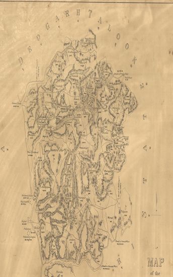
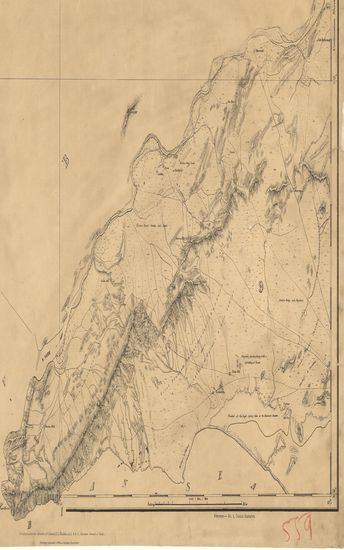
- Map of the Darwha Taluka : east berar.
- Year: 1875
-
-
-
-
-
-
-
-
-
-
-
-
-
-
-
-
-
-
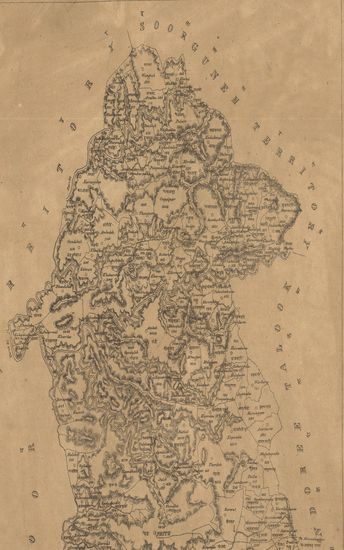
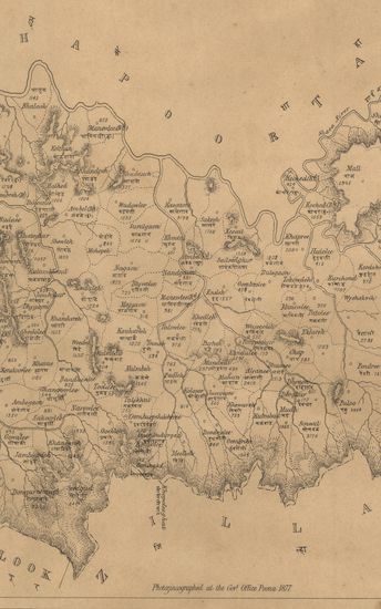
- Map of the Malvan Taluka of the Ratnagiri Zilla.
- Year: 1877
- Subject: Topographic Map
- Publisher: Poona (Pune) Government Photozincographic Office 1877
- Language: English
- Place of Publication: Poona (Pune)
-
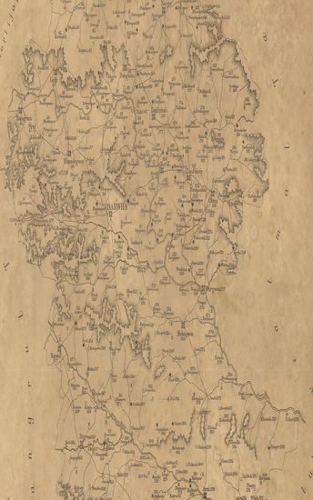
- Map of the Peith State of the Nasik (Nashik) Zilla.
- Subject: Topographic Map
- Publisher: Poona (Pune) Government Photozincographic Office
- Language: English
- Place of Publication: Poona (Pune)
-
- Map of the Darwha Taluka : east berar.
- Year: 1875
- Publisher: Poona (Pune) Photozincographed Government Office 1875
- Language: English
- Place of Publication: Poona (Pune)
-
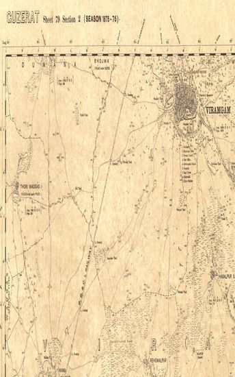
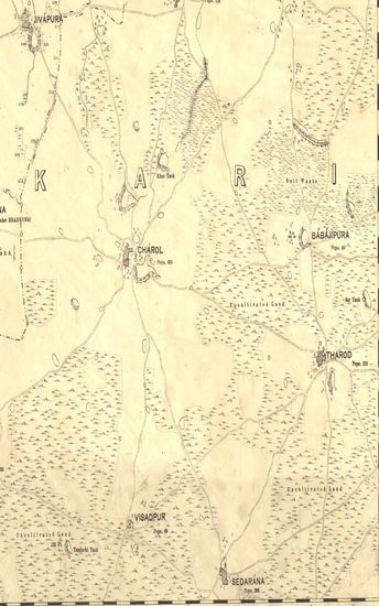
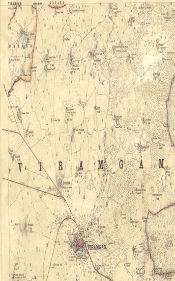
- Guzerat, Sheet 79 Section 1 : Parts of the Viramgam taluka Ahmedabad collectorate, Kari taluka Baroda State, and of the Dasara State (Season 1875-76)
- Year: 1877
- Subject: Topographic Map
- Publisher: Dehradhun G.T.S. Office 1877
- Language: English
- Place of Publication: Dehradhun
-
- Guzerat, Sheet 78 Section 3 : Parts of the Viramgam Taluka Ahmedabad Collectorate and Kari Taluka Baroda State (Season 1875-76)
- Year: 1877
- Subject: Topographic Map
- Publisher: Dehradun G.T.S Office 1877
- Language: English
- Place of Publication: Dehradun
-
- Map of the Pimpulneir Talooka Khandesh including the Petta of Nizampoor. - नकाशा तालुके पिंपळनेर जिल्हा खानदेश .
- Year: 1870
- Subject: Topographic Map
- Publisher: Poona (Pune) Government Photozincographic Office 1870
- Language: English
- Place of Publication: Poona (Pune)
-
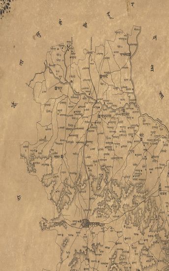
- नकाशा तालुके यवतमाळ जिल्हा वराड . - Map of Yavatmal Taluka District Varad .
- Year: 1875
- Subject: Topographic Map
- Publisher: Poona (Pune) Government Photozincographic Office 1875
- Language: English
- Place of Publication: Poona (Pune)
-
- District Kurrachee [Karachi] (Kohistan & Sehwan) Surveyed in 1863-64. Sind Revenue Survey (Sheet No.38)
- Year: 1870
- Subject: Cadastral Map
- Publisher: Calcutta Surveyor General's Office 1870
- Language: English
- Place of Publication: Calcutta
-
- District Kurrachee (Karachi) Surveyed in 1855-56. Sind Revenue Survey (Sheet No.69)
- Year: 1869
- Subject: Cadastral Map
- Publisher: Calcutta Surveyor General's Office 1869
- Language: English
- Place of Publication: Calcutta
-
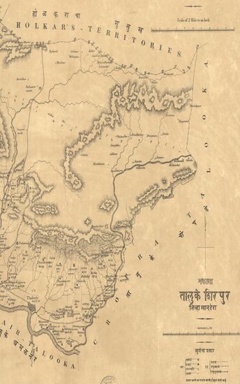
- Map of the Sirpoor (Shirpur) Taluka, Khandesh Collectorate.
- Year: 1873
- Subject: Topographic Map
- Publisher: Poona (Pune) Government Photozincographic Office 1873
- Language: English
- Place of Publication: Poona (Pune)
-
- Map of the Moorbad Talooka, Tanna Collectorate.
- Year: 1877
- Subject: Topographic Map
- Publisher: Poona (Pune) Government Photozincographic Office 1877
- Language: English
- Place of Publication: Poona (Pune)
-
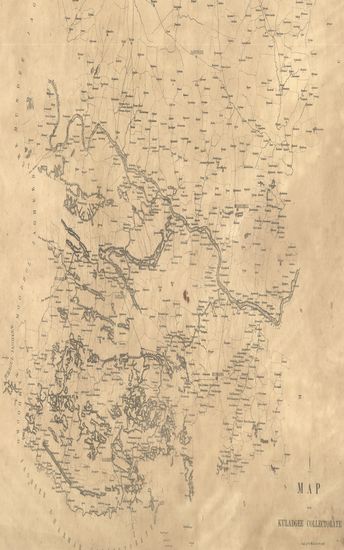
- Map of the Kuladgee ( Kaladgi ) Collectorate.
- Subject: Topographic Map
- Publisher: Poona (Pune) Government Photozincographic Office
- Language: English
- Place of Publication: Poona (Pune)
-
- Gujerat, Sheet 79 Section 3 : Parts of Sanand Taluka of the Ahmedabad Collectorate and of the Kari Taluka Baroda State(Season 1875-76)
- Subject: Topographic Map
- Publisher: Scales dIffer [2:10560] Scale. Two Inches to One Mile (Feet = 2 Miles)
- Language: English
- Place of Publication: Scales dIffer
-
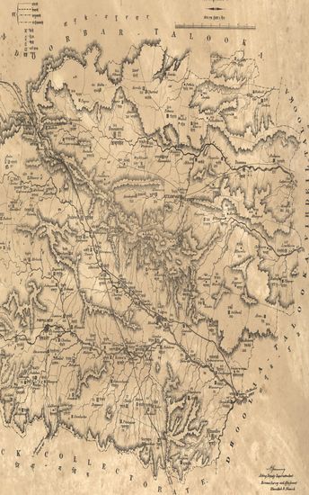
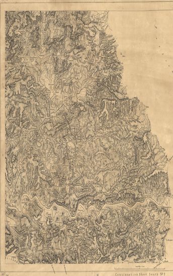
- Portion of Hoshungabad & Baitool (Hoshangabad & Betul). Season 1867-68-69. Central Provinces Topographical Survey. (Sheet No.2)
- Year: 1871
- Subject: Topographic Map
- Publisher: Calcutta Surveyor General's Office 1871
- Language: English
- Place of Publication: Calcutta
-
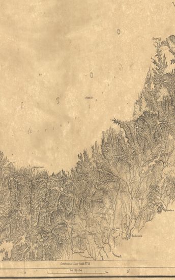
- Portion of Hoshungabad & Baitool (Hoshangabad & Betul) . Season 1866-67-68. Central Provinces Topographical Survey. (Sheet No.4)
- Year: 1871
- Subject: Topographic Map
- Publisher: Calcutta Surveyor General's Office 1871
- Language: English
- Place of Publication: Calcutta
-
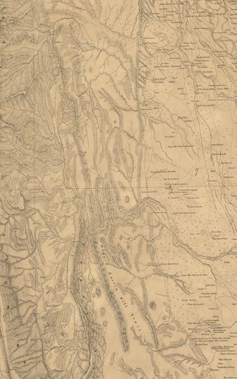
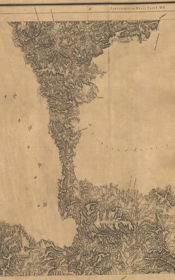
- Portion of Baitool (Betul) & Berar. Season 1866-67-68 & 69. Central Provinces topographical survey. (Sheet No.10)
- Year: 1871
- Subject: Topographic Map
- Publisher: Calcutta Surveyor General's Office 1871
- Language: English
- Place of Publication: Calcutta
-
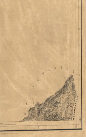
- Portions of Baitool (Betul). Season 1868-69-70. Central Provinces Topographical Survey. (Sheet No. 8)
- Year: 1871
- Subject: Topographic Map
- Publisher: Calcutta Surveyor General's Office 1871
- Language: English
- Place of Publication: Calcutta
-
- Portion of Baitool (Betul). Season 1867-68-69. Central Provinces Topographical Survey. (Sheet No.15)
- Year: 1871
- Subject: Topographic Map
- Publisher: Calcutta Surveyor General's Office 1871
- Language: English
- Place of Publication: Calcutta
-
- Portion of Baitool (Betul). Season 1868-69-70. Central Provinces Topographical Survey. (Sheet No.9)
- Year: 1870
- Subject: Topographic Map
- Publisher: Calcutta Surveyor General's Office 1870
- Language: English
- Place of Publication: Calcutta
-
- Portion of Baitool ( Betul ). Season 1867-68. Central Provinces Topographical Survey. (Sheet No.5)
- Year: 1871
- Subject: Topographic Map
- Publisher: Calcutta Surveyor General's Office 1871
- Language: English
- Place of Publication: Calcutta