-
- 16 Views
-
- 9 Views
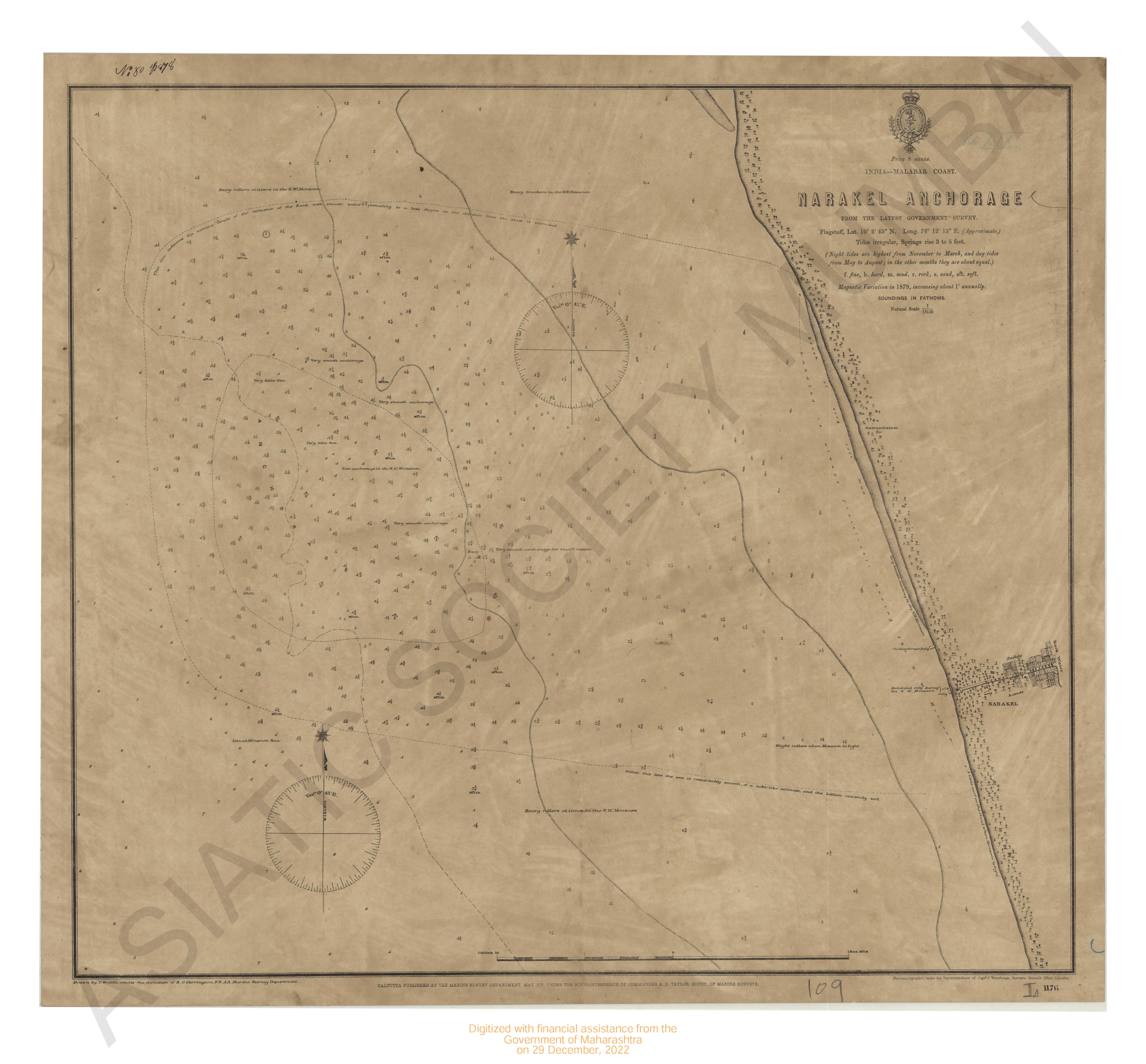
- India - Malbar coast, Narakal Anchorage
- Year: 1878
-
- 1 View

-

-
- 1 View
-
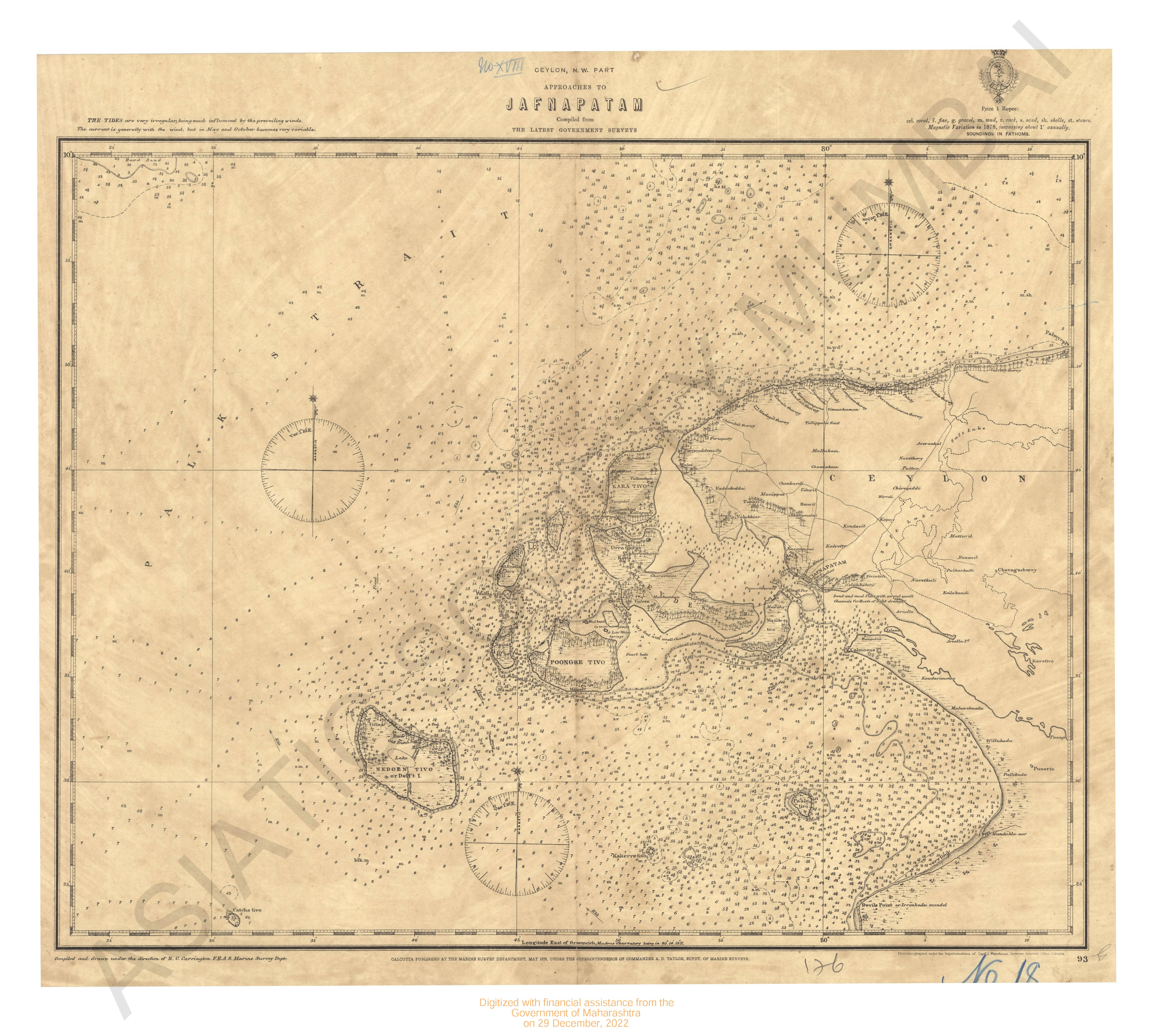
- Ceylon N.W.part approaches to Jafnapatam
- Year: 1878
-
- 3 Views
-
- 2 Views
-
- 3 Views
-
- 7 Views
-
- 2 Views
-
- 2 Views
-
- 4 Views
-
- 5 Views
- India- west coast Portugese territory Goa
- Year: 1877
-
- 5 Views
-
- 1 View
- India - East Coast. Madras roadstead
- Year: 1876
-
- 9 Views
-
- 4 Views
-
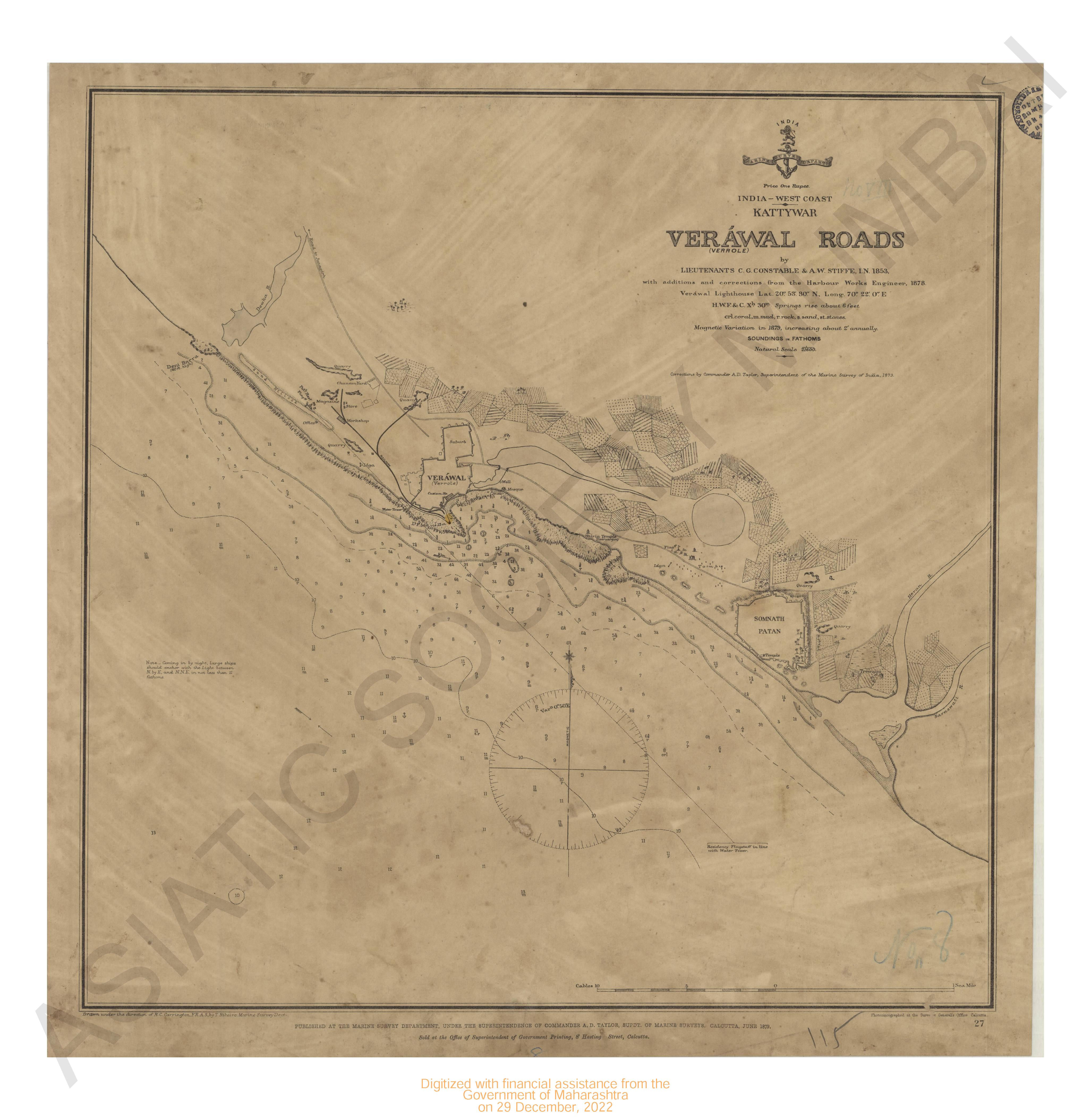
- India - west coast . Kattywar Verawal roads
- Year: 1879
-
- 3 Views
-
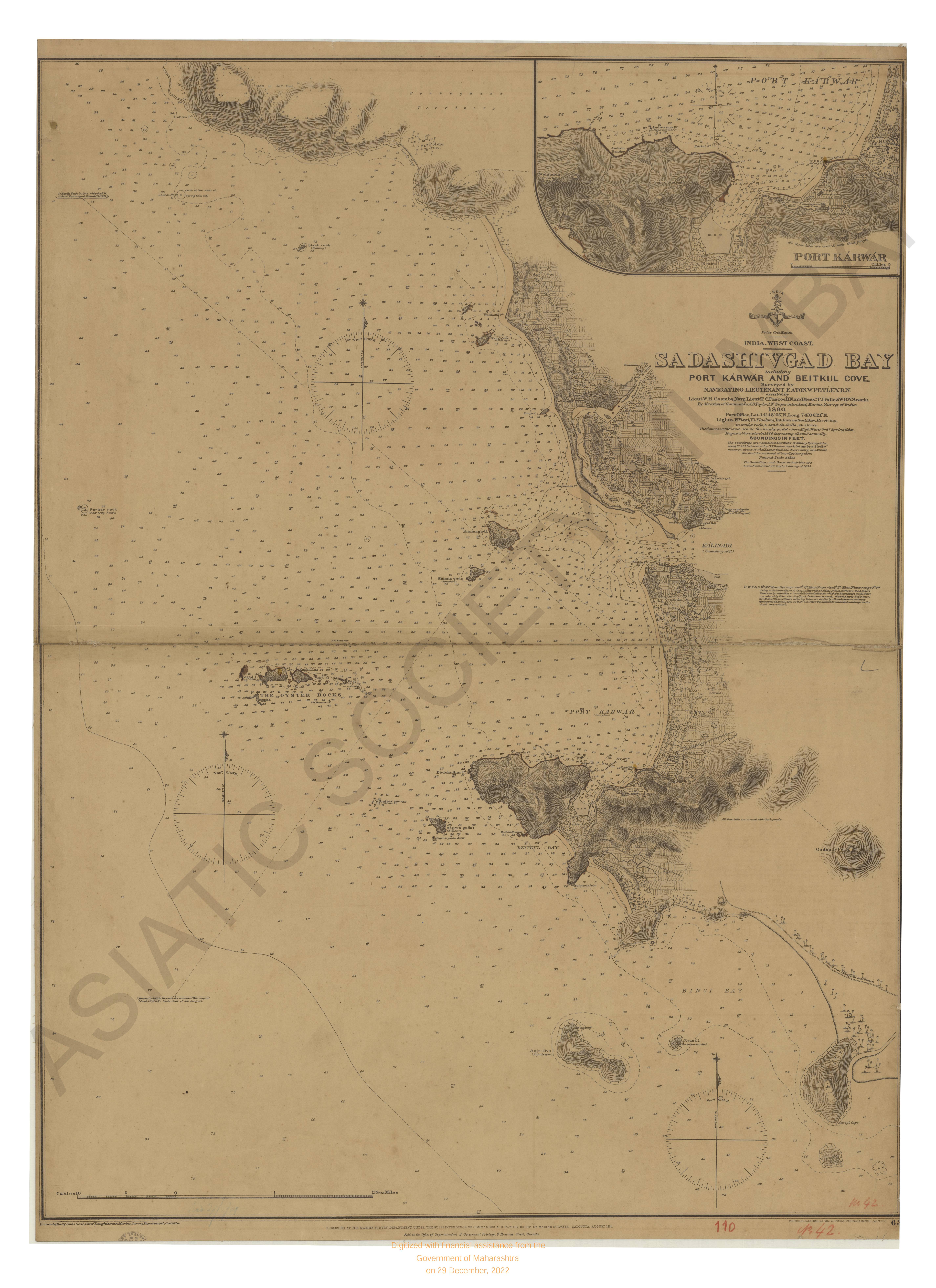
- India- West coast. Sadashivgad bay including port karwar and Beitkul cove
- Year: 1881
- Subject: Topographic Map
- Publisher: Marine Surveyor Department
- Language: English
- Place of Publication: Calcutta
- 16 Views
-
- India - Malbar coast, Narakal Anchorage
- Year: 1878
- Subject: Topographic Map
- Publisher: Marine Surveyor Department
- Language: English
- Place of Publication: Calcutta
- 9 Views
-
- Districts Bunno and Derah Ishmaeel Khan with the kabul kheyl and Mahsood Wuhsood Wuzeree Hills. Upper Derahjat 1856-61.
- Year: 1864
- Subject: Topographic Map
- Publisher: Marine Surveyor Department
- Language: English
- Place of Publication: Calcutta
- 1 View
-
- Derah Ghasze khan district, lower Derahjat, 1856-59
- Year: 1861
- Subject: Topographic Map
- Publisher: Marine Surveyor Department
- Language: English
- Place of Publication: Calcutta
-
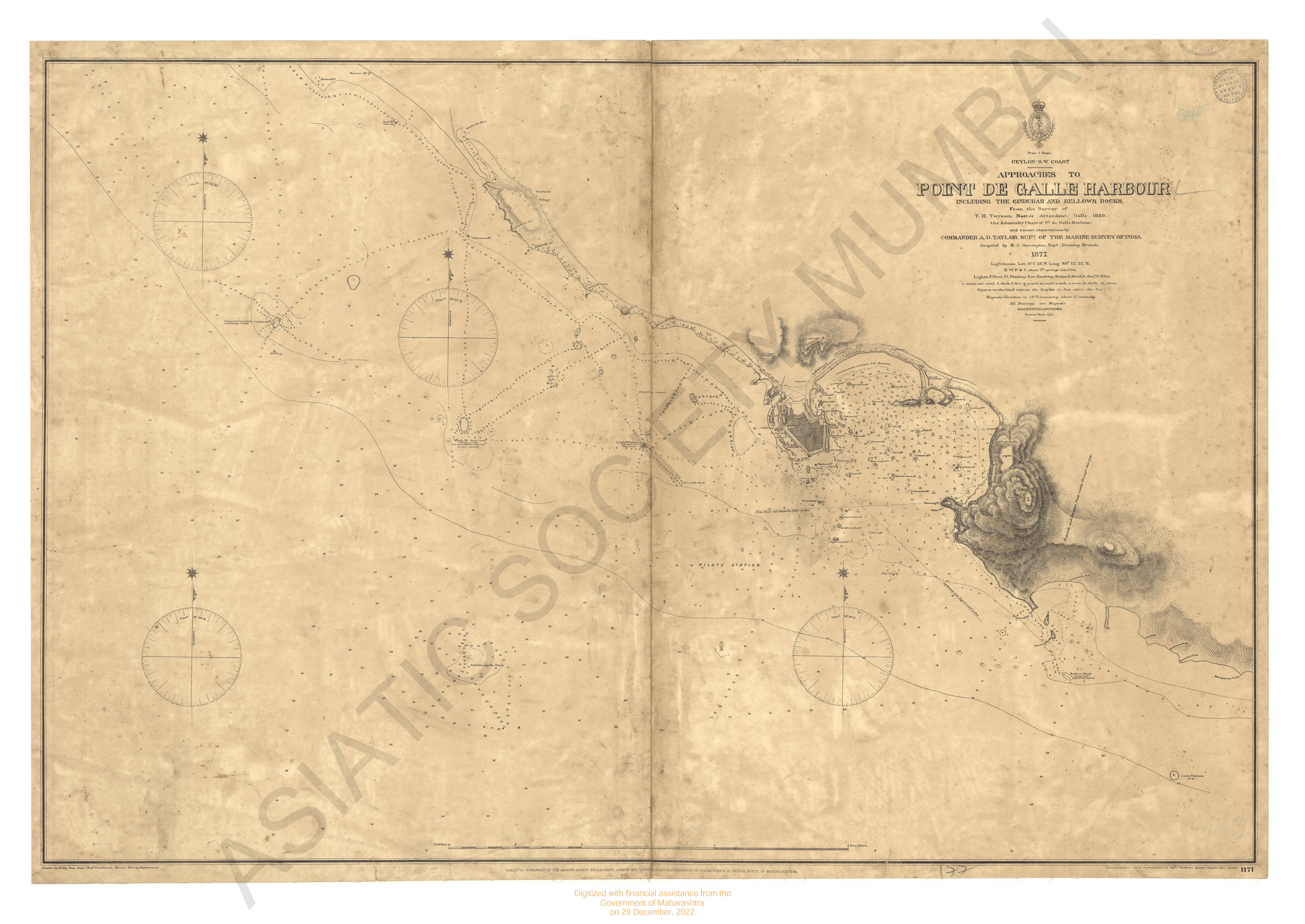
- Ceylon S.W. coastm approaches to point De Galle Harbour; including the Gindurah & Bellows rocks.
- Year: 1877
- Subject: Topographic Map
- Publisher: Marine Surveyor Department
- Language: English
- Place of Publication: Calcutta
- 1 View
-
- Ceylon N.W.part approaches to Jafnapatam
- Year: 1878
- Subject: Topographic Map
- Publisher: Marine Surveyor Department
- Language: English
- Place of Publication: Calcutta
-
- India; Bay of Bengal; false point to Mutlah river showing the approaches to the sandheads from the Latest govt. Surves 1877
- Year: 1877
- Subject: Topographic Map
- Publisher: Marine Surveyor Department
- Language: English
- 3 Views
-
- India- west coast. Jayyad (Fyghur) & entrance to the shastri river.
- Year: 1880
- Subject: Topographic Map
- Publisher: Marine Surveyor Department
- Language: English
- Place of Publication: Calcutta
- 2 Views
-
- India- west coast (sheet-1) karanchi to vingorla
- Year: 1887
- Subject: Topographic Map
- Publisher: Marine Surveyor Department
- Language: English
- Place of Publication: Calcutta
- 3 Views
-
- India- west coast; Kundhari id to chart including chart kadu reef.
- Year: 1880
- Subject: Topographic Map
- Publisher: Marine Surveyor Department
- Language: English
- Place of Publication: Calcutta
- 7 Views
-
- India- west coast, Gulf of Cutch approaches to Cutch Mandvi
- Year: 1879
- Subject: Topographic Map
- Publisher: Marine Surveyor Department
- Language: English
- Place of Publication: Calcutta
- 2 Views
-
- India- East coast. Narsapur point to palmyras point ( the Vizagapatam, Ganjam & orissa coast)
- Year: 1877
- Subject: Topographic Map
- Publisher: Marine Surveyor Department
- Language: English
- Place of Publication: Calcutta
- 2 Views
-
- India- west coast, Dabhol and entrance to washishti river.
- Year: 1880
- Subject: Topographic Map
- Publisher: Marine Surveyor Department
- Language: English
- Place of Publication: Calcutta
- 4 Views
-
- India- west coast Portugese territory Goa
- Year: 1877
- Subject: Topographic Map
- Publisher: Marine Surveyor Department
- Language: English
- Place of Publication: Calcutta
- 5 Views
-
- India- west coast chart & entrance to kundalika river
- Year: 1880
- Subject: Topographic Map
- Publisher: Marine Surveyor Department
- Language: English
- Place of Publication: Calcutta
- 5 Views
-
- India - East Coast. Madras roadstead
- Year: 1876
- Subject: Topographic Map
- Publisher: Marine Surveyor Department
- Language: English
- Place of Publication: Calcutta
- 1 View
-
- India west coast Ratnagiri including Mirya & Kaldadevie & bays
- Year: 1879
- Subject: Topographic Map
- Publisher: Marine Surveyor Department
- Language: English
- Place of Publication: Calcutta
- 9 Views
-
- India- West coast. Rajpur bay and viziadurg with adjacent coast.
- Year: 1879
- Subject: Topographic Map
- Publisher: Marine Surveyor Department
- Language: English
- Place of Publication: Calcutta
- 4 Views
-
- India - west coast . Kattywar Verawal roads
- Year: 1879
- Subject: Topographic Map
- Publisher: Marine Surveyor Department
- Language: English
- Place of Publication: Calcutta
-
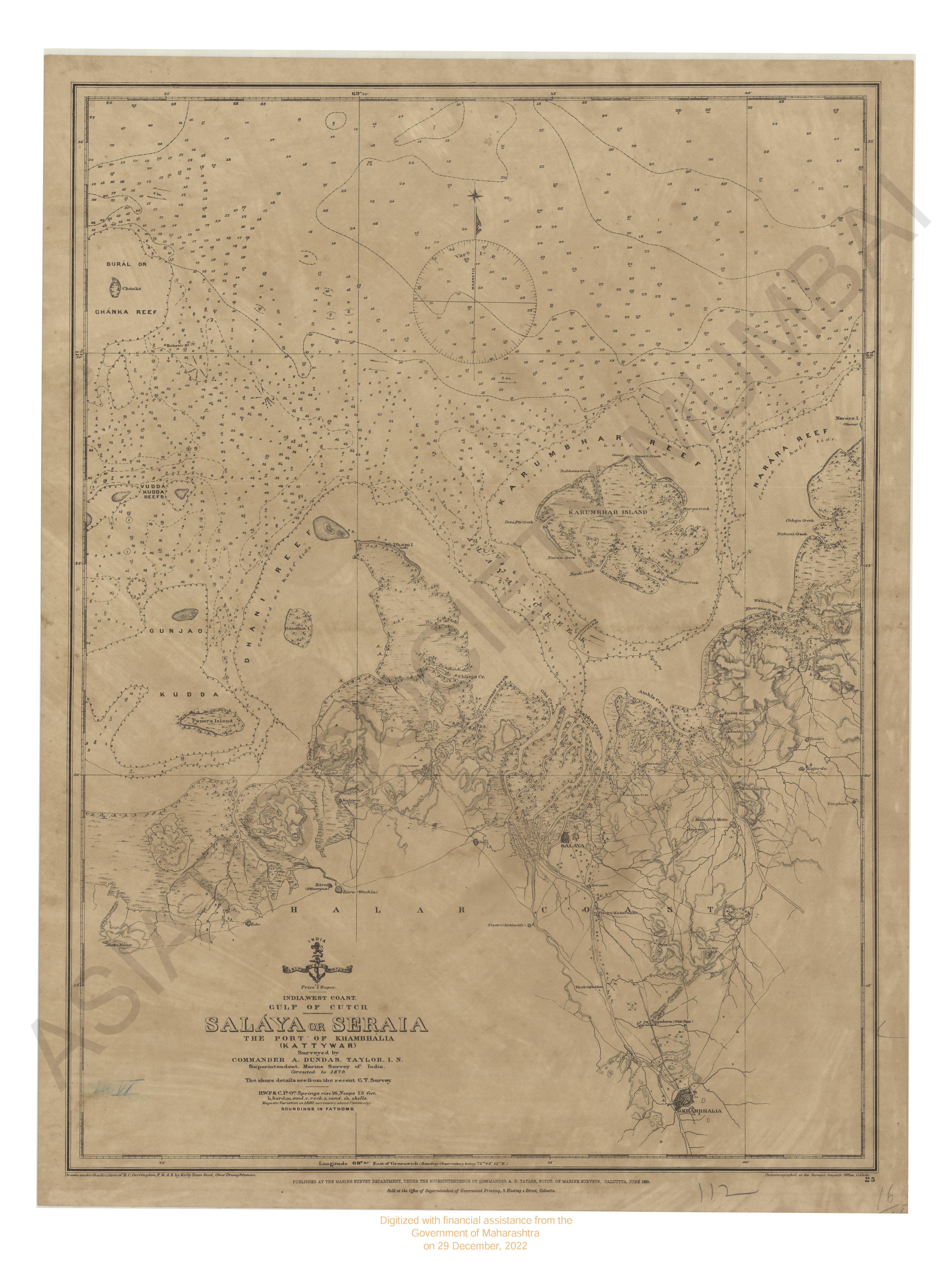
- India - West coast Gulf of Cutch, Salaya or Seraia. The Port of Khambhalia (katlywar) Surveyed & corrected in 1879.
- Year: 1880
- Subject: Topographic Map
- Publisher: Marine Surveyor Department
- Language: English
- Place of Publication: Calcutta
- 3 Views