-
- 2 Views
-
- 3 Views
-
- 2 Views
-
- 4 Views
-
-
-
-
-
-
-
-
-
-
-
-
-
-
- 261 Views
-
- 119 Views
-
- 68 Views
- Guzerat, Sheet 80 Section 16 : Part of Dholka Taluka of ...
- Year: 1877
- Author: Haig, C.T.
-
- Gujarat : parts of the Parantij taluka of the Ahmedabad collectorate - section 1 (season 1877-78)
- Year: 1880
- Subject: Topographic Map
- Publisher: Office of the Trigonometrical Branch, Survey of India
- Language: English
- Place of Publication: Dehradun
- 2 Views
-
- Gujarat : parts of the Ahmedabad collectorate, of the Gaiwar, Territory and of the Mahikanta states. Trigonometrical branch survey of India. Season 1878-79 and 1879-80
- Year: 1881
- Subject: Topographic Map
- Publisher: Office of the Trigonometrical Branch, Survey of India
- Language: English
- Place of Publication: Dehradun
- 3 Views
-
- Gujarat : parts of the Parantij taluka and Ahmedabad collectorate season. 1879-80
- Year: 1881
- Subject: Topographic Map
- Publisher: Office of the Trigonometrical Branch, Survey of India
- Language: English
- Place of Publication: Dehradun
- 2 Views
-
- Premlinary chart of the Mangoler meridional series, season 1865-66& 1866-67. great Trigonometrical survey of India
- Year: 1870
- Subject: Topographic Map
- Publisher: Office of the supdt. Great Trigonometrical survey
- Language: English
- Place of Publication: Dehradun
- 4 Views
-
- Turkestan and the countries between the British and the Russian dominions in Asia 4th ed. Sheet No.4
- Year: 1879
- Subject: Topographic Map
- Publisher: Office of the Great Trigonometrical survey of India
- Language: English
- Place of Publication: Dehradun
-
- Turkestan and the countries between the British and the Russian dominions in Asia 4th ed. Sheet No.3
- Year: 1879
- Subject: Topographic Map
- Publisher: Office of the Great Trigonometrical survey of India
- Language: English
- Place of Publication: Dehradun
-
- Turkestan and the countries between the British and the Russian dominions in Asia 4th ed. Sheet No.2
- Year: 1879
- Subject: Topographic Map
- Publisher: Office of the Great Trigonometrical survey of India
- Language: English
- Place of Publication: Dehradun
-
- Turkestan and the countries between the British and the Russian dominions in Asia 4th ed.
- Year: 1879
- Subject: Topographic Map
- Publisher: Office of the Great Trigonometrical survey of India
- Language: English
- Place of Publication: Dehradun
-
- Turkestan with the adjoining portions of the British, Russina and Native territories, 2nd ed. Sheet No.4
- Year: 1873
- Subject: Topographic Map
- Publisher: Office of the Great Trigonometrical survey of India
- Language: English
- Place of Publication: Dehradun
-
- Turkestan with the adjoining portions of the British, Russina and Native territories, 2nd ed. Sheet No.3
- Year: 1873
- Subject: Topographic Map
- Publisher: Office of the Great Trigonometrical survey of India
- Language: English
- Place of Publication: Dehradun
-
- Turkestan with the adjoining portions of the British, Russina and Native territories, 2nd ed. Sheet No.2
- Year: 1873
- Subject: Topographic Map
- Publisher: Office of the Great Trigonometrical survey of India
- Language: English
- Place of Publication: Dehradun
-
- Turkestan with the adjoining portions of the British, Russina and Native territories, Sheet No.1
- Year: 1873
- Subject: Topographic Map
- Publisher: Office of the Great Trigonometrical survey of India
- Language: English
- Place of Publication: Dehradun
-
- Turkestan with the adjoining portions of the British, Russina and Native territories
- Year: 1875
- Subject: Topographic Map
- Publisher: Office of the Great Trigonometrical survey of India
- Language: English
- Place of Publication: Dehradun
-
- Turkestan and the countries between the British and the Russian dominions in Asia. 5th ed. Sheet No.3.
- Year: 1881
- Subject: Topographic Map
- Publisher: Survey of India Offices
- Language: English
- Place of Publication: Dehradun
-
- Turkestan and the countries between the British and the Russian dominions in Asia. 5th ed. Sheet No.4.
- Year: 1881
- Subject: Topographic Map
- Publisher: Survey of India Offices
- Language: English
- Place of Publication: Dehradun
-
- Turkestan and the countries between the British and the Russian dominions in Asia. 5th ed. Sheet No.2.
- Year: 1881
- Subject: Topographic Map
- Publisher: Survey of India Offices
- Language: English
- Place of Publication: Dehradun
-
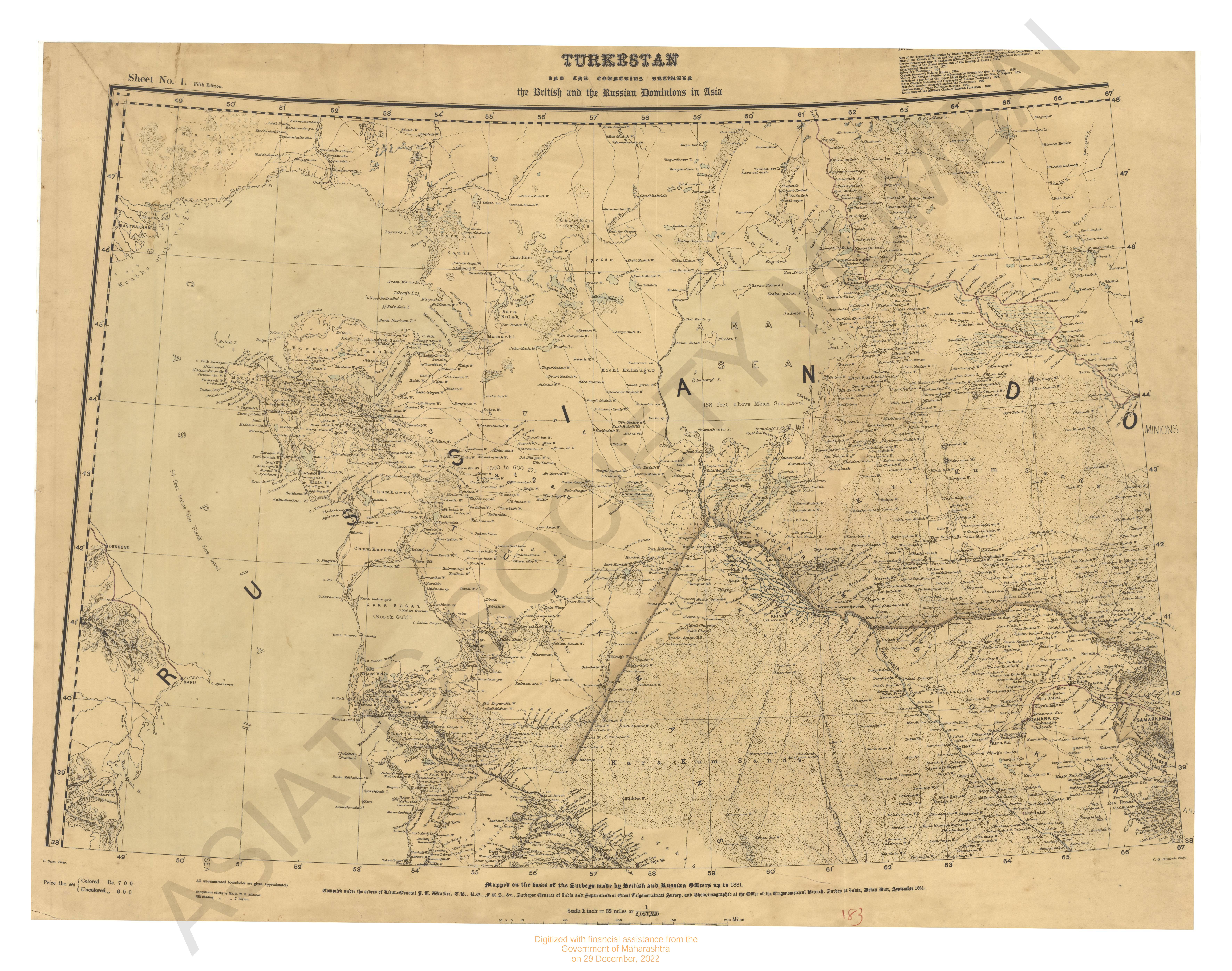
- Turkestan and the countries between the British and the Russian dominions in Asia. 5th ed. Sheet No.1.
- Year: 1881
- Subject: Topographic Map
- Publisher: Survey of India Offices
- Language: English
- Place of Publication: Dehradun
-
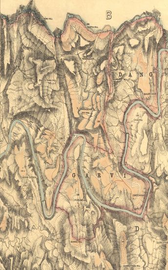
- Guzerat Section No.4 of Sheet No. 49(Dang Forests) : Parts of the Dang Garvi, Dang Derbhauti, and Dang Pimpri States. 1877-78
- Year: 1879
- Subject: Topographical States
- Publisher: Dehradun Office of the Trigonometrical Barnch. Survey Of India 1879
- Language: English
- Place of Publication: Dehradun
- 261 Views
-
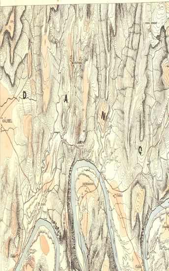
- Guzerat, Section No.3 of Sheet No.49 (Dang Forests) : Part of the Dang Garvi and Dang Koita States, 1877-78
- Year: 1879
- Subject: Topographic Map
- Publisher: Dehradun Office of the Trigonometrical Branch. Survey Of India 1879
- Language: English
- Place of Publication: Dehradun
- 119 Views
-
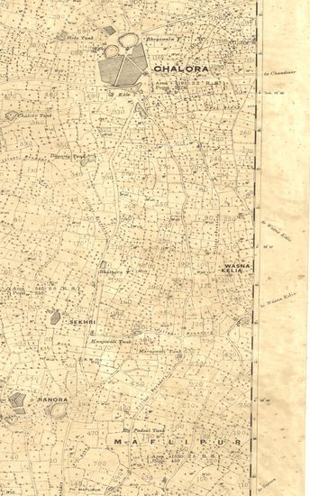
- Guzerat, Sheet 80 Section 16 : Part of Dholka Taluka of the Ahmedabad Collectorate (Season 1873-74)
- Year: 1877
- Author: Haig, C.T.
- Subject: Topographic Map
- Publisher: Dehradun G.T.S Office 1877
- Language: English
- Place of Publication: Dehradun
- 68 Views